| Share this: | ||||

|

|

|

|

|
|
DCNR Releases First Report On The Impacts Of Drilling In State Forest Lands
|
|
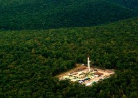
The Department of Conservation and Natural Resources Wednesday released a copy of its first monitoring report on the impact of shale gas drilling in State Forests based on 15 different monitoring values developed by agency scientists with input from its advisory committees. The report covers activities from 2008 to 2012 and was released at a meeting of the agency’s Natural Gas Advisory Committee in State College. The 268-page monitoring report covered impacts to infrastructure, flora, forest health, invasive species, water, soil, air, incidents, fauna, recreation, community engagement, timber, energy, revenue and forest landscapes. DCNR will also hold a webinar on the report on April 21 at 1:30. Click Here to register or call toll-free 877-668-4493. DCNR is also collecting observations about the report through an online survey. “People may have different perspectives on how monitoring is defined, but they want to know that staff is on the ground observing and managing gas development activity that is occurring in our state forests,” said DCNR Secretary Ellen Ferretti. “The breadth and depth of this report demonstrates that shale gas production on state forests is being carefully managed.” “Monitoring does not necessarily give you answers – it gives you data to be used for decision-making,” Ferretti said. “We already have and continue to make adjustments based on our observations, and our management guidelines will continually be updated as more information is brought forth.” “The intent of the report is to present information in as objective a manner as possible. Oftentimes trends or effects are not evident for years or decades. Despite that, there are some findings that can be gleaned from this initial report,” Acting Deputy Secretary for Parks and Forestry Dan Devlin said. Shale gas development on State Forest lands has resulted in $583.2 million dollars revenue to the state through 2012 and in the conversion of 1,486 acres to facilitate gas development over the 385,400 acres of leased State Forest land. All of the shale gas leases were signed before 2011. DCNR pointed out it has added 8,900 acres of new State Forest land to the forest districts where gas is being developed. About 15 percent of the shale gas produced in Pennsylvania comes from State Forest lands the report said. DCNR noted even with shale gas development it has retained the Forest Stewardship Council sustainable forest certification, including after a 2013 comprehensive five-year re-certification audit which resulted in no major corrective action requests. DEP investigated 324 incidents involving drilling sites in State Forests from 2008 through 2012 which resulted in 308 notices of violation. The report said two of those incidents were a diesel fuel spill and a brine spill. In addition, DCNR’s own reporting system found 264 incidents in 50 different categories related to shale gas development. Water monitoring at over 300 sites in State Forests and by the Susquehanna River Basin Commission’s real-time monitoring network have not identified any significant impacts due to shale gas development, although the report cautioned these results were from the first round of sampling which was largely baseline sampling. The report pointed out that 87 percent of the streams in the shale gas region are classified as high quality or exceptional value. In terms of recreational experiences on State Forest lands, the report said noise levels at 6 of the 7 compressor stations on state lands were above the levels recommended in the environmental standards in state leases. A limited survey of 116 State Forest land users found that 46 said gas development had changed their visitation experience and recreational use of these areas, but little follow-up detail was provided. The report said invasive species are a concern as areas of disturbance tend to create conditions conducive to invasion of unwanted plant species or pests. Invasive species need to be carefully managed and controlled. DCNR leases require that companies address invasive species. As a result of current shale gas leases, DCNR anticipates a total of approximately 3,000 gas wells will be drilled on State Forest lands when fully developed. There were about 568 wells drilled by the end of 2013. DCNR also said the agency is just beginning to receive royalties from the shale gas development as actual gas production increases. Click Here for a copy of the full report. Click Here for an executive summary. The following are the findings from DCNR’s monitoring report. Infrastructure — Approximately 1,486 acres of forest have been converted to facilitate gas development in the core gas districts (state forests subject to shale gas development), including roads, infrastructure and well pads and pipelines. During the same time period (2008 to 2012), the bureau acquired 33,500 acres to add to state forest system, including 8,900 acres in core gas forest districts. — One hundred and sixty-one total miles of road have been improved or constructed for shale-gas development in the core gas districts. Of these, 131 miles of state forest roads that existed prior to the shale-gas development have been improved or upgraded for gas development activities, and 30 miles of new roads have been constructed for gas development activities. — One hundred and ninety-one infrastructure pads have been constructed to facilitate shale-gas development in the core gas forest districts. — One hundred and four miles of pipeline corridor have been constructed or widened in the core gas forest districts. Flora — A majority of forest conversion for the construction of gas infrastructure on state forest lands occurs in the dry oak-heath community type. — In undisturbed forest habitat surrounding pads, New York fern (Thelypteris noveboracensis) and hay-scented fern (Dennstaedtia punctilobula) had the highest average percent cover in the understory, with 31.2 percent and 31 percent cover respectively. — The most prevalent species in areas around the edges of pads re-vegetated with erosion and sedimentation control seed mixes were Festuca species, with 19.2 percent average percent cover, Orchardgrass (Dactylis glomerata, 16.0 percent), and red clover (Trifolium pratense, 14.2 percent). Forest Health — The bureau participates with the USDA Forest Service in the Forest Health Monitoring Program, a national program designed to determine the status, changes, and trends in indicators of forest condition on an annual basis. — The principal damage-causing agents from 2008 to 2012 in the core gas forest districts were gypsy moth, forest tent caterpillar, and frost. — Impacts to the forest surrounding disturbance can only be discovered through long-term forest health monitoring Invasive Species — Eleven non-native invasive plant species were present at 14 of 18 representative pads across core gas forest districts. The invasive plant with the largest mean population size was Japanese stilt-grass (Microstegium vimineum). — Increased susceptibility to pest attack, especially by nonnative invasive species, may occur wherever there is forest disturbance, especially for trees along newly created edges. However, impacts in the surrounding forests can be discovered only through long-term forest health monitoring. Water — The majority of streams in the core gas forest districts (71 percent) are first-order, headwater streams. — The majority of streams in the shale-gas region (87 percent) are classified as high quality or exceptional value by the DEP, and many streams are identified as having naturally reproducing trout populations by the Fish and Boat Commission. — A widespread sampling of field chemistry, including over 300 locations, showed that pH results were primarily in the circum-neutral range, with 72 percent of results between 6.5 and 7.5 and a median pH of 7.01. — A widespread sampling of field chemistry showed that 91 percent of specific conductance results were below 100 microsiemens(μS)/cm, with a median of 41.3 μS/cm. — Initial water monitoring results have not identified any significant impacts due to shale-gas development. This is based on one round of field chemistry sampling throughout the shale-gas region and over a year of operation for 10 continuous monitoring devices in key watersheds. At this early stage, the data collected are primarily for establishing baseline conditions. — Future monitoring efforts include longitudinal surveys of field chemistry, surface water grab sampling, installation of continuous monitoring devices, and an assessment of pipeline-stream crossings Soil — To the extent possible, placement of shale-gas infrastructure has avoided wet soils and soils with high runoff potential. — Of all pads, impoundments, and compressors constructed, over 85 percent were on well-drained to excessively well-drained soils, and over 80 percent were on soils with medium to very low surface runoff index. — Of all pipelines constructed, over 70 percent occurred within well-drained to excessively well-drained soils and within soils with medium to very low surface runoff index. — Of all roads newly constructed or improved due to shale-gas development, over 80 percent occurred within well-drained to excessively well-drained soils and within soils with medium to very low surface runoff index. — Future research and monitoring will focus on the effects of well pad construction on soil physical and chemical properties, as well as the effects of best management practices on hydrology and sediment loads. Air — Since shale-gas development began in Pennsylvania in 2008, there has been a marked decrease in several major air pollutants, such as sulfur, nitrogen oxides, and carbon dioxide. This is due, in part, to the increased use of natural gas for power generation, the shutdown of several major facilities, and the installation of air pollution control equipment. — Short-term air sampling at several locations around the state (by DEP) has detected natural gas constituents and associated compounds in the vicinity of shale-gas operations. These compounds were not detected at concentrations that would likely cause health-related impacts, although some were detected at levels which would produce an odor. — A one-year study is under way in southwest Pennsylvania (by DEP) to study the potential long-term and cumulative effect of air emissions from compressor stations and a major processing facility. A study is also under way to examine the concentrations of ground-level ozone in the vicinity of shale-gas operations. — A short-term air quality study in Ramsey Village, in Lycoming County along the Pine Creek Rail Trail, did not detect air pollutants above rural background conditions Incidents -- From 2008 through 2012, DEP investigated 324 incidents on state forest land, resulting in 308 notices of violations (NOVs). -- From July 1, 2009, through 2012, 264 incidents in 50 different categories were reported through the bureau Incident Reporting System across all state forest districts directly related to gas development activity. Fauna — Wildlife habitat will change due to shale-gas infrastructure, resulting in more edge and early successional habitat. — The bureau is monitoring the positive and negative impacts of shale-gas development on wildlife communities to better understand their long-range implications and steps that can be instituted to avoid and mitigate negative impacts. — The bureau is in the early stages of developing its wildlife monitoring protocols. The bureau will focus on monitoring changes in habitat conditions in relation to shale-gas development — Through its monitoring program, the bureau is funding multiple research projects to advance the understanding of the impacts of shale-gas development to wildlife species, such as interior forest birds and timber rattlesnakes. Recreation — No national hiking trails in Pennsylvania have been impacted by shale-gas development. Three designated state forest hiking trails have been impacted. — Statewide, since 2006, there has been a 5 percent increase (145 miles) in total snowmobile trail miles across the state forest system. This is the result of a 203-mile decrease in joint-use trails and a 348-mile increase in designated snowmobile trails. — Snowmobile trail systems have been impacted in each of the core gas forest districts. New snowmobile trails have been created to replace impacted snowmobile trails. — The need for road access for shale-gas development has resulted in heavier traffic on state forest roads. Upgraded roads may be safer and easier to drive but may have lost some of their “wild character” value. — The impact of shale-gas development on recreational experience and wild character as measured by the Recreation Opportunity Spectrum is a 9,341-acre increase in semi-developed and developed acreage; a 913-acre decrease in semi-primitive acreage; an 8,409-acre decrease in semi-primitive non-motorized acreage; and a 19-acre decrease in primitive acreage.— Initial measurements at six out of the seven operating compressor stations measured on state forest lands were louder than the 55db(A) suggested by the updated Guidelines for Administering Oil and Gas Activity on State Forest Lands. — Forty-six out of 116 comment card respondents in core gas forest districts indicated that Marcellus activity had changed their visitation experience. Forty-one out of 116 respondents indicated that Marcellus activity had changed their recreational use of the state forest. Community Engagement — Natural gas development on state forest lands has potential economic and social effects on local communities. — The bureau uses advisory committees to promote stakeholder feedback and produce recommendations — Outreach offers valuable opportunities to demonstrate how natural gas activity is conducted and managed on public lands and has become a source of understanding public perceptions. — Focus groups have been designed to identify and understand the social effects on communities resulting from natural gas development on state forest lands. One pilot focus group targeting community leaders in Pine Creek Valley was conducted in November of 2013. Two additional groups targeting government leaders in Tioga and Clinton counties were conducted in 2014. Timber — Initial analysis shows that some timber management activities in core gas forest districts may be shifting away from areas leased for shale-gas development. Some of this change, however, may be due to gypsy moth salvage harvesting. — The effect of shale-gas development on timber harvest placement and harvest allocation goals is inconsistent across core gas forest districts. More information and data are needed to discern reliable trends. — Shale-gas development is indirectly decreasing timber harvest revenue due to Route 44 bonding costs resulting from heavy hauling associated with shale-gas development Energy — Approximately 15 percent of all shale gas produced in Pennsylvania comes from state forest lands. This gas is sold and distributed across the eastern and midwestern United States to service energy markets on a daily basis. — Natural gas in the United States is an open-market traded commodity that has seen the price per product unit fall from a high of approximately $10 per Mcf (1,000 cubic feet) in 2010 to the current (end of 2013) $4.75 per Mcf as a direct result of Pennsylvania shale gas coming onto the market grid and forcing gas prices to moderate with respect to the gas supply. — On state forest land, the number of wells per pad ranges from one to ten, with approximately four to eight wells being the average. A typical well drains approximately 100 acres, but that figure can be less or greater depending on a number of factors. — The bureau anticipates that approximately 3,000 gas wells may be drilled on state forest lands to fully develop the current leased acreage on commonwealth gas leases, on which approximately 568 had been drilled by the end of 2013. A portion of these new wells will be drilled on existing well pads. — State forest lease tracts targeting shale gas are estimated to be approximately one-fifth developed. This, however, is only a projection, as future energy development patterns are difficult to accurately predict and depend on market conditions and the performance of individual tracts. Revenue — The pre-shale-gas period of oil and gas activity provided a total income to the commonwealth of approximately $153,659,522. The shale-gas period (through 2012, for the purposes of this report) has provided $582,250,644 in revenue. The combined total of all revenue from the oil and gas lease program from 1947 to the end of 2012 has been approximately $735,910,166. — The influx of shale-gas production revenue began in 2009 when most of the wells that had been first proposed in 2007, 2008, and early 2009 were drilled and connected to the pipeline system and gas was delivered to the market. — Royalty income is just beginning to come to DCNR from the hundreds of new shale-gas wells on state forest land. — Steady revenue growth from gas extraction is expected to continue for the next decade as the full development of the leases comes to a conclusion. Forest Landscapes — approximately 1,486 acres of the 2.2 million acre state forest system has been converted to facilitate shale-gas development. During the same time period (2008 to 2012), the bureau acquired 33,500 acres to add to state forest system, including 8,900 acres in the core gas forest districts. — One assessment of the current impact of gas infrastructure on wild character, using the Recreation Opportunity Spectrum as a measurement tool, is a 9,340-acre increase in semi-developed and developed acreage. Correspondingly, there was a 912-acre decrease in semi-primitive area, an 8,409-acre decrease in semi-primitive non-motorized area, and a 19-acre decrease in primitive area. — In core gas forest districts, the bureau’s forest fragmentation analysis showed the largest increases in edge forest in Tiadaghton State Forest (1,813 acres) and Tioga State Forest (1,257 acres). Overall, core gas forest districts added 4,355 acres of edge forest. — In the core gas forest districts, there was a loss of 9,242 acres of core forest greater than 200 hectares. Core forests are large parcels of interior forest not affected by roads, pipelines, well pads, and other infrastructure. Elk, Moshannon, and Tiadaghton state forests have had a combined total of 10 well pads that have been partially reclaimed by reducing the pad size and replanting the adjacent areas with vegetation. No gas infrastructure sites have received full ecological restoration Reaction Cindy Dunn, President & CEO of PennFuture, released this statement in reaction to the report, "We are pleased to finally see the Marcellus monitoring report and applaud the effort of agency staffers tasked with its release. At a glance, the report raises more questions than it answers. When will DCNR release the raw data analyzed in the report? Was the report peer-reviewed by outside experts? How will the general public, and scientific professionals, be able to provide input on an ongoing basis? What changes has DCNR made, or will it make, based on the analysis and conclusions in the report? How many forest acres have been indirectly and cumulatively impacted by the 1,486 acres converted to gas infrastructure? "We remain unequivocally opposed to additional leasing of our state parks and forests for natural gas drilling. It's time we put the brakes on runaway drilling – the gas is under our land and it's not going anywhere. We owe it to the citizens of the Commonwealth to more fully understand the impacts of natural gas drilling before we turn special places into industrial zones. The suggestion that this industrial activity can be 'carefully managed' provides scant comfort to Pennsylvanians who frequent Penn's Woods. Carefully-managed industrialization is still industrialization, so the need for a moratorium on leasing of state forests and parks to drillers remains. "PennFuture is collaborating with environmental and conservation organizations in the state to review this report in the interest of a larger, public conversation on drilling of public lands." Capitolwire.com reported the Governor’s Energy Executive Patrick Henderson as saying, "Contrary to the doom and gloom from the far left, like PennFuture, PennEnvironment and Clean Water Action – two of whom oppose all shale gas development under any circumstances, preferring instead to get their gas from a utility instead of the earth – the report was well received by the Advisory Committee," said Henderson, who regularly butts heads with those organizations. "Reasonable groups like PA Environmental Council, Trout Unlimited, the Nature Conservancy, etc. that serve on the committee and spent four hours discussing (rather than 10 minutes writing a press release) may provide a more accurate perspective that is worthy of consideration. Several of the members of the committee praised DCNR for the thoroughness and professionalism of the report." Neither the PA Environmental Council nor the Nature Conservancy have issued any statements or opinions about DCNR’s Monitoring Study. For more information, visit DCNR’s Natural Gas Development and State Forests webpage. NewsClips: State Reaps $582M Windfall On Gas Drilling In State Forests State Forests Becoming Less Wild With Growth Of Drilling DCNR Report Quantifies Marcellus Impacts On Public Lands DCNR Releases First Marcellus Monitoring Report Report On Gas Drilling In State Forests Released Drilling In State Forests, Impacts And Trade-Offs Op-Ed: Corbett Drilling Plan Is Good For Parks Editorial: More State Park, Forest Drilling Means More Disturbance Another GOP Lawmaker Backs Drilling Industry Tax Want To Be Governor? Give Fracking Windfall To The People Letter: State Is Good Steward Of Drilling On Public Lands Editorial: Pressure Rises For Fair Tax On Natural Gas DEP: Wastewater Leaked From Range Drilling Impoundment DEP Investigates Drilling Wastewater Leak In Washington County Gas Drilling Wastewater Leak Found In Amwell |
|
|
4/21/2014 |
|
| Go To Preceding Article Go To Next Article |