 04/15/24 - 66 New Stories - REAL Environmental & Conservation Leadership In PA: http://tinyurl.com/msuwtctm
| Share this: | ||||

|

|

|

|

|
|
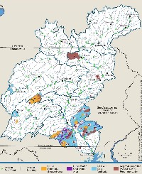
Susquehanna River Commission Report Shows 9% Of Watersheds Are Stressed, Critical
|
|
The Susquehanna River Basin Commission Monday released a new report, Cumulative Water Use and Availability Study for the Susquehanna River Basin, which shows about 9 percent of the watersheds in the basin, almost all in Pennsylvania, show a potential for water use limitations and warrant further limitation. Potentially stressed areas for availability of water in the future in Pennsylvania, included the Manheim/Lititz/Ephrata Valley, Fruit Belt (York/Adams Counties), Hanover area, Hershey area (Spring Creek basin), Fredericksburg area, Roaring Spring area, and State College area. The report also identified these areas as candidates for Critical Water Area Designations in Pennsylvania, including Toby Creek, Spring Creek, Nittany Creek, Anderson Creek, Sugar Creek, Little Catawissa Creek, Conestoga River, Chiques Creek, Swatara Creek, Beaverdam Branch, Conewago Creek, Codorus Creek, and Deer Creek (see page 47 of the full report). Of these, Spring Creek, Sugar Creek, Toby Creek, and tributaries to Conewago Creek, Conestoga River, and Swatara Creek were recommended for designation as CWPAs by DEP’s State Water Plan regional committees. The actual amount of water used in the Susquehanna Basin was 370 million gallons per day in 2014. Actual use is expected to increase to 400 million gallons per day by 2030. The biggest users of water were-- public water supply-- 95.5 million gallons per day, electric generation 92.1 million gallons, agriculture-- 51 million, natural gas-- 27.2 million, manufacturing-- 16.8 million, mining 8.7 million, other 15.8 million gallons per day. The report said 1 billion gallons of water are approved to be withdrawn or used by industry and the public every day in the Susquehanna River Basin. This approved use is expected to grow to 1.2 billion gallons per day by 2030. The largest approved users are-- public water supplies- 453.8 million gallons, electric generation-- 208 million, natural gas-- 116 million, agriculture-- 63.1 million, manufacturing-- 45.1 million, mining- 25.3 million and other-- 63.4 million gallons. The total water availability for the Susquehanna Basin was calculated to be 3.3 billion gallons per day. This report represents the Commission’s most comprehensive evaluation to date that characterizes water use and availability. This multi-year effort is a part of the Commission’s mission to wisely manage the water resources of the Basin to assure short-term resource availability and long-term balance between healthy ecosystems and economic viability. The purpose of the study was to closely examine sustainability within the context of water uses, needs, and the natural availability of water resources. “The study provides valuable insight regarding the state of water use and availability in the Susquehanna River Basin, along with an evaluation of the effectiveness of various low flow management measures,” states Andrew Dehoff, P.E., and the Commission’s Executive Director. “This report also provides the framework for ongoing assessments and enhances public access to our data.” Overall, water availability for most Basin watersheds was found to be adequate to satisfy approved water use quantities. However, certain areas of the Basin do show potential for future conflicts and warrant further examination. The study also suggests that current management practices should have a positive effect on managing water resources during a drought and provides insight into areas where additional management measures can increase water sustainability. In addition to the report, planning tools have been developed to allow continued assessment of water use and availability throughout the Basin. A publically accessible, interactive web map was developed for use by the regulated community, partner agencies and organizations, and the public. The web map displays map layers depicting approved and reported water use and water availability summarized by watershed. A copy of the report and supporting documents are available on a special SRBC webpage. Click Here for a summary of the report. NewsClips: Drought Watch In 34 Pa Counties, 1 In Drought Warning 9 Midstate Counties Under Drought Watch Water Levels Low At Allegheny Reservoir Related Stories: Conservation Districts Asked By DEP For Yes Or No On Conducting Farm Inspections Penn State Extension Doing Follow-Up Visits To 700 Farms In Chesapeake Bay Survey CBF-PA: DEP Must Include Threat To Bass In Susquehanna River Impairment Report DEP Lists Lower Susquehanna As Impaired For Recreation, Not Aquatic Uses 4,267 More Miles Of Streams Listed As Impaired By DEP, Lower Susquehanna Not Listed |
|
|
8/8/2016 |
|
| Go To Preceding Article Go To Next Article |