| Share this: | ||||

|

|

|

|

|
|
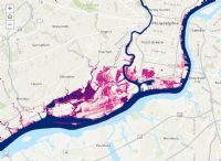
DEP Coastal Zone Committee Jan. 15: $430 Million In Property Value At Risk On Southeast PA Coast Due To Climate Change, Regardless Of Greenhouse Gas Emission Limits
|
|
The DEP Coastal Zone Advisory Committee is scheduled to meet on January 15 and on the agenda is a presentation by the Delaware Valley Regional Planning Commission on projected impacts of climate change and resulting sea level rise in Southeast coastal areas. Chris Linn, from the Commission, will present the Coastal Effects of Climate Change in Southeastern PA online story map which describes the potential impacts of several sea level rise scenarios. The Greater Philadelphia area is expected to see an increase of from 3 to 8 degrees above current temperatures, depending on future trends in greenhouse gas emissions. Increasing temperatures are predicted to cause rising sea levels across the globe. Along the North Atlantic coast of the United States, sea level is predicted to rise at a higher rate than the global average. This is due to many region-specific geologic and oceanographic processes, but a primary factor is that land in this region is sinking slowly due to subsidence. The water levels of the tidal section of the Delaware River will rise as sea level rises along the Atlantic Coast. These rising water levels will be a permanent change to the landscape and will introduce new flooding vulnerabilities along the Delaware that communities will need to address. The analysis shown in the story map calculates coastal flood heights for the years 2050 and 2100 by adding projected sea level rise onto the flood height calculated by the National Oceanic and Atmospheric Administration for the current 1 percent flood (also known as “100-year” flood). In Pennsylvania and New Jersey, sea level is expected to rise approximately another 1.0 to 1.8 feet by 2050 (1.4 feet being the central estimate) from a base year of 2000) and could rise approximately 1.7 to 4.5 feet by 2100 (3.4 feet being the central estimate), depending on the low or high greenhouse gas emissions levels projected. The Commission’s analysis found regardless of whether a high- or low-emissions scenario is used to forecast sea level rise, the projections for 2050 are very similar. The maps in the analysis compares differences in areas flooded during storms and the 100-year flood event and areas that would be chronically flooded because of permanent sea level rise. This analysis indicates approximately 42 miles of roadway, 75 community assets, and 498 structures are at risk of chronic inundation in 2050. The property value at risk of chronic inundation is $430 million. That number climbs to $920 million in property value at risk in the high emissions scenario. The story map presentation also reviews the potential savings in national flood insurance premiums if communities in the coastal zone participated in the federal Community Rating System which awards points to communities for a variety of activities, including activities relating to public information, mapping and regulations, flood hazard mitigation, and warning and response. Visit the Coastal Effects of Climate Change in Southeastern PA story map that will be used in the presentation and explore how coastal flooding may affect you. Click Here for more on climate resiliency from the Delaware Regional Planning Commission. The meeting will be held in the 12th Floor Conference Room of the Rachel Carson Building in Harrisburg starting at 9:30. For more information and available handouts, visit the DEP Coastal Zone Advisory Committee webpage. Questions should be directed to Stacey Box by calling 717-772-5622 or sending email to: sbox@pa.gov. (Photo: Blue areas are present day high tide areas, the pink areas are expected chronic inundation areas starting in 2050- dark- regardless of emission levels, 2100- lighter pink-low emissions scenario, 2100- lightest pink-high emissions scenario.) NewsClips: 250+ PA Environment & Energy NewsClips From Last Week Waiting To Be Read Related Article - Statewide Flooding: Related Articles - Climate Change: Gov. Wolf Sets Goal Of Reducing Greenhouse Gas Emissions By 80% By 2050 From 2005 Levels Senate Environmental Committee Holds Briefing On Joining RGGI New Poll Finds 79% Of Pennsylvania Voters Support Limits On Carbon Pollution From Power Plants [Posted: January 5, 2020] |
|
|
1/6/2020 |
|
| Go To Preceding Article Go To Next Article |