| Share this: | ||||

|

|

|

|

|
|
Water Science Institute Storymap Shows How Old Mill Dams, Land Use & Legacy Sediments In Lancaster County Affect Water Quality
|
|
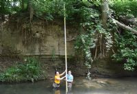
On June 11, the Water Science Institute (WSI) officially released its latest education and research tool “Legacy Landscapes” to support Chesapeake Bay Watershed Awareness Week and ongoing water quality improvement initiatives throughout the region. The storymap illustrates how historic mill dam removal and land use practices affect Lancaster County and the Chesapeake Bay watershed with an emphasis on nutrient and sediment releases and mitigation efforts to alleviate their effects on water quality. Utilizing research from WSI and Franklin and Marshall scientists, the project focuses on the current contributions of dam breaches to high nutrient and sediment loads using a combination of field investigation, academic analysis, lidar imagery, digital elevation modeling and drone surveys. The combination of historic and contemporary sources is integrated into a visual narrative demonstrating the significance of stream bank erosion that affects local and Bay water cleanup goals. Pre and post removal examples trace the consequences of nutrient and sediment loads from the Susquehanna River flats of the upper Bay to their origins in current “hotspots” at the Conowingo Dam and in Lancaster County’s Chiques Creek watershed. Other highlights of the map provide viewers with aerial and scientific results of the Growing Greener funded Big Spring Run restoration and an accompanying synopsis of best management practice (BMP) cost effectiveness which together demonstrate the conservation opportunities that can be attained through well designed dam removal and restoration projects. The map is part of the Water Science Institute’s examination of dam removal practices and policies with funding from the Department of Environmental Protection’s Growing Greener program. Visit the Legacy Landscapes webpage to learn more. For more information on this and other projects, visit the Water Science Institute website. (Photo: F&M students measure sediment left behind from old mill dam.) Resource Links: Video - Legacy Sediments, Floodplain Restoration With Mark Gutshall, Landstudies Related Articles - Legacy Sediments: F&M Highlights Big Spring Run Stream, Floodplain Restoration Efforts In Lancaster Rock Lititz Project Reduces Sediment, Nutrient Runoff Without Taxpayer Money Brubaker Run Floodplain Restoration Public-Private Project In Lancaster County Related Article This Week: [Posted: June 11, 2020] |
|
|
6/15/2020 |
|
| Go To Preceding Article Go To Next Article |