| Share this: | ||||

|

|

|

|

|
|
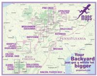
Penn State Cartographer Parlayed Love Of Nature Into Purple Lizard Maps That's Helping People Social Distance
|
|
By David Kubarek, Penn State News It took a global pandemic to convince many of something Mike Hermann has long known: We are surrounded by some amazing outdoor attractions. Hermann, founder of the adventure map company Purple Lizard Maps and a 1995 Penn State geography alumnus, said he founded the company after attending the University and realizing how little people knew about the area that surrounds them. Since 1997, he’s parlayed his love of geography and outdoor landscapes into his business venture. Since March, he’s seen an uptick in the number of people seeking social-distancing solace in the forests via hiking, biking, boating and other activities for which Purple Lizard was designed to promote. “Right now, you’re seeing a tremendous amount of people who are suddenly spending a lot more time outdoors,” Hermann said. “And I’m hopeful that this will start to influence their lifestyle choices long term.” Birth of Purple Lizard Hermann started the company after earning a geography degree, but the story begins long before that. After high school, he sought an engineering degree from Penn State, but soon realized it wasn’t right for him. He spent his 20s working in the outdoor retail industry while exploring the region’s forests. When he returned to Penn State, he knew a little more about what he wanted to do. He knew that he preferred classes related to art and writing and design over other topics, and he found geography to check all of those boxes. The degree earned him a job in Denver, working for Trails Illustrated of National Geographic Maps, seemingly a dream job for an avid mountain biker. But the 18-month jaunt made him realize how much he loved Pennsylvania. For every epic daylong journey in the Rocky Mountains, there was a great after-work exploration in Pennsylvania that so few people knew about. Purple Lizard became Hermann’s way to tell them. “Even to this day, people will tell me about this great hiking trip that they did in some faraway location,” Hermann said. “They’ll tell me about this old growth hemlock forest or something else that they found. And I’m like ‘that’s great that you drove seven hours to see this, but don’t you know that you live 30 minutes from one?’” In fact, much of his business comes from out-of-state or out-of-country people wanting to explore what the state’s tourism bureau has deemed the “Pennsylvania Wilds.” Curation is the key What’s different about Purple Lizard is that it’s highly curated content with an intent for outdoor use. That’s why the maps are waterproof and fold to pocket size. That’s also why Hermann and his team rely on a boots-on-the-ground approach to mapmaking. A satellite image can tell you much about the main roads, but little in the way of what’s under the thick overgrowth of the forest. It also can’t tell you about the user experience. The painstaking approach to mapmaking is why the user shares an experience that’s been vetted by the creators. It’s also why Purple Lizard produces just one map per year. To date, the company offers about a dozen maps across regions of Pennsylvania, Ohio, West Virginia and Puerto Rico. The goal, Hermann says, is a product that shows users a range of experiences that can be found in a given region, without all the extra noise that more broad-use maps can have. “If you compare our maps to ones by Google or U.S. Geological Survey or Pennsylvania Department of Conservation and Natural Resources trail maps, they all tell a certain story,” Hermann said. “But it’s not necessarily the story that an outdoor person wants to read.” Hermann said he wants to foster the sense of discovery while also educating users about forest norms and etiquette. One example he gives with the recent uptick in traffic is letting users know they shouldn’t expect to find trash cans in the parking lots because they attract bears. His investment in "1% For The Planet" is geared towards protecting these areas for future generations. Ripe for growth Purple Lizard landed just as outdoor activities were becoming more mainstream. “Our parents didn’t ride bikes,” Hermann said. “It wasn’t seen as something a grownup did. They joined country clubs. They weren’t buying mountain bikes. They weren’t building self-sustaining sprinter vans or cars with rooftop tents. Everything that we’re doing now are things that the previous generation viewed as things that you should outgrow. I think that’s what's really led, in no small part, to this big growth of outdoor interest in general.” The shift for people and families wanting to discover and explore nature propelled Purple Lizard from a part-time business (Hermann worked for Penn State and the University of Maine, where he was senior cartographer for the award winning “Historical Atlas of Maine”) into a full-time operation. Several of the team’s cartographers are also Penn State geography alumni who collaborate with Hermann on the map compilation and design. That concept of discovery can be traced to the name itself. The "Purple Lizard Maps" has come to signify something worth exploring on the map. That’s how the company labels hidden gems that defy description: Instead of trying, they slap a purple lizard on the spot and allow the users to decide. Hermann dreamed up the brand by combining two of his loves, chasing lizards as a child and reading the children’s book “Harold and the Purple Crayon” by Crockett Johnson, a book he still keeps. “In the book, Harold can take his purple crayon and sort of draw his reality,” Hermann said. “He can draw a trail up the mountain and start walking. And I thought, wow, that’s just like mapmaking.” [Visit the Purple Lizard Maps website to learn more. [Visit the Get Outdoors Pennsylvania, Explore PA Trails and DCNR websites to find recreational opportunities near you.] (Reprinted from Penn State News.) Related Articles: DCNR Celebrates Rivers Month And Lackawanna River As Pennsylvania’s 2020 River Of The Year Dept. Of Health WalkWorks Program Adds Partners, 100 Walking Routes [Posted: June 22, 2020] |
|
|
6/29/2020 |
|
| Go To Preceding Article Go To Next Article |